Importing Switzerland’s Airspaces
We import data on the Switzerland’s airspaces from OpenAIP and convert it to OpenAir format using one of the following tools:
We use this data to build a dataframe that can be used with the rest of our code.
Latest data: http://www.openaip.net/system/files/airspaces/openaip_airspace_switzerland_ch.aip_1600822879
Note that OpenAIP requires a (free) account to download files.
We use python-openair to process the OpenAir file, ensure this is installed and on your PYTHONPATH.
Setup
Modify the location below to point to the OpenAir file.
openair_file = "/mnt/cold_data/josh/dumped/openaip_airspace_switzerland_ch.txt"
import openair
import requests
from datetime import datetime, timezone
import time
import numpy as np
import pandas as pd
import descartes, geopandas
import cartopy
from shapely.geometry import LineString, Point, Polygon, MultiPolygon, base
import pyproj
from shapely.ops import transform, unary_union
import math
import matplotlib.pyplot as plt

import cartopy.crs as ccrs
import cartopy.geodesic as cgeo
import cartopy.io.img_tiles as cimgt
import cartopy.feature as cfeature

import re
heightstring = r"^(?P<fl>(FL|fl) ?(?P<fl_val>\d+))|(?P<msl>(?P<msl_val>\d+) ?(msl|MSL))|(?P<agl>(?P<agl_val>\d+) ?(agl|AGL))|(?P<fl_agl>(?P<fl_agl_val>\d+) ?(fl|FL) (agl|AGL))|(?P<m_agl>(?P<m_agl_val>\d+) ?(m|M) (agl|AGL))|(?P<gnd>gnd|GND)|(?P<f_msl>(?P<f_msl_val>\d+) ?(f|F) (msl|MSL))|(?P<f_gnd>(?P<f_gnd_val>\d+) ?(f|F) (gnd|GND))$"
positionstring = r"^(?P<ns_d>\d{1,2}):(?P<ns_m>\d{1,2}):(?P<ns_s>\d{1,2}) ?(?P<ns>[NS]) ?(?P<ew_d>\d{1,3}):-?(?P<ew_m>\d{1,2}):(?P<ew_s>\d{1,2}) ?(?P<ew>[EW])$"

expression_height = re.compile(heightstring)
expression_position = re.compile(positionstring)
Initial Data Processing
The airspaces are loaded from the OpenAir file and turned into a DataFrame with the help of a parsing library and a series of regular expressions.
airspaces = openair.parseFile(openair_file)
df = pd.DataFrame(airspaces)

df.columns = ['name', 'upper_limit_raw', 'lower_limit_raw', 'coords_raw']
def metre_to_ft(x):
    return x * 3.28084

def process_height(string):
    match = expression_height.match(string)
    if match is not None:
        if match.group('fl') is not None:
            return int(match.group('fl_val')) * 100
        elif match.group('msl') is not None:
            return int(match.group('msl_val'))
        elif match.group('agl') is not None:
            return int(match.group('agl_val'))
        elif match.group('fl_agl') is not None:
            return int(match.group('fl_agl_val')) * 100
        elif match.group('m_agl') is not None:
            return metre_to_ft(int(match.group('m_agl_val')))
        elif match.group('f_msl') is not None:
            return int(match.group('f_msl_val'))
        elif match.group('f_gnd') is not None:
            return int(match.group('f_gnd_val'))
        elif match.group('gnd') is not None:
            return 0
        else:
            raise Exception(string)
    else:
        raise Exception(string)
def position_to_decimal(degrees, minutes, seconds, direction):
    return direction * (degrees + ((1/60) * minutes) + ((1/3600) * seconds))

def process_position(string):
    match = expression_position.match(string)
    if match is not None:
        ns_deg = int(match.group('ns_d'))
        ns_min = int(match.group('ns_m'))
        ns_sec = int(match.group('ns_m'))
        ns_dir = 1 if match.group('ns') == "N" else -1
        latitude = position_to_decimal(ns_deg, ns_min, ns_sec, ns_dir)

        ew_deg = int(match.group('ew_d'))
        ew_min = int(match.group('ew_m'))
        ew_sec = int(match.group('ew_m'))
        ew_dir = 1 if match.group('ew') == "E" else -1
        longitude = position_to_decimal(ew_deg, ew_min, ew_sec, ew_dir)

        return [latitude, longitude] # TODO figure out if right way round
    else:
        raise Exception(string)

def process_positions(positions):
    if isinstance(positions, list):
        return [ process_position(pos) for pos in positions ]
    else:
        return None

def coords_to_points(coords):
    if coords is None:
        return geopandas.points_from_xy([], [])
    lats, longs = zip(*coords)
    return geopandas.points_from_xy(longs, lats)

def geometry_lambda(positions):
    poly = Polygon(coords_to_points(process_positions(positions))).buffer(0)
    if isinstance(poly, Polygon):
        return MultiPolygon([poly])
    else:
        return MultiPolygon(poly)
df['lower_limit'] = df.lower_limit_raw.apply(process_height)
df['upper_limit'] = df.upper_limit_raw.apply(process_height)
df['coords'] = df.coords_raw.apply(process_positions)
df['geometry'] = df.coords_raw.apply(geometry_lambda)
df
| name | upper_limit_raw | lower_limit_raw | coords_raw | lower_limit | upper_limit | coords | geometry | |
|---|---|---|---|---|---|---|---|---|
| 0 | A9.1 AIRWAY | FL 195 | FL 90 | [47:15:18 N 008:58:21 E, 47:13:03 N 008:55:26 ... | 9000 | 19500 | [[47.25416666666667, 8.982777777777779], [47.2... | (POLYGON ((8.982777777777779 47.25416666666667... |
| 1 | A9.2 AIRWAY | FL 195 | FL 130 | [47:02:49 N 008:56:49 E, 46:52:13 N 008:58:16 ... | 13000 | 19500 | [[47.03388888888889, 8.94888888888889], [46.88... | (POLYGON ((8.94888888888889 47.03388888888889,... |
| 2 | Aiguilles Rouges 300m AGL | 3300F GND | GND | [45:55:20 N 006:50:06 E, 45:55:21 N 006:49:49 ... | 0 | 3300 | [[45.93194444444444, 6.847222222222222], [45.9... | (POLYGON ((6.847222222222222 45.93194444444444... |
| 3 | Alpen Mil off | FL 195 | FL 150 | [46:22:02 N 006:48:18 E, 46:31:43 N 007:03:52 ... | 15000 | 19500 | [[46.37277777777778, 6.8133333333333335], [46.... | (POLYGON ((6.813333333333333 46.37277777777778... |
| 4 | Alpen Mil on | FL 195 | FL 130 | [46:22:02 N 006:48:18 E, 46:31:43 N 007:03:52 ... | 13000 | 19500 | [[46.37277777777778, 6.8133333333333335], [46.... | (POLYGON ((6.813333333333333 46.37277777777778... |
| ... | ... | ... | ... | ... | ... | ... | ... | ... |
| 147 | ZURICH 5 TMA 118.1 | FL 195 | 3500F MSL | [47:29:54 N 008:54:28 E, 47:26:19 N 008:53:32 ... | 3500 | 19500 | [[47.49138888888889, 8.915000000000001], [47.4... | (POLYGON ((8.915000000000001 47.49138888888889... |
| 148 | ZURICH 6 TMA 118.1 | FL 195 | 5500F MSL | [47:46:04 N 008:25:06 E, 47:43:28 N 008:18:17 ... | 5500 | 19500 | [[47.779444444444444, 8.42361111111111], [47.7... | (POLYGON ((8.423611111111111 47.77944444444444... |
| 149 | ZURICH 7 TMA 118.1 | FL 195 | 7500F MSL | [47:18:10 N 008:22:40 E, 47:13:56 N 008:25:55 ... | 7500 | 19500 | [[47.305, 8.372777777777777], [47.220277777777... | (POLYGON ((8.372777777777777 47.305, 8.4236111... |
| 150 | ZURICH 8 TMA 118.1 | FL 195 | 6500F MSL | [47:38:34 N 008:00:00 E, 47:34:34 N 007:59:59 ... | 6500 | 19500 | [[47.64388888888889, 8.0], [47.57611111111112,... | (POLYGON ((8 47.64388888888889, 7.999722222222... |
| 151 | ZURICH 9 TMA 118.1 | FL 195 | 7500F MSL | [47:51:45 N 008:46:30 E, 47:49:51 N 008:39:21 ... | 7500 | 19500 | [[47.86416666666667, 8.779444444444444], [47.8... | (POLYGON ((8.779444444444444 47.86416666666667... |
152 rows × 8 columns
gdf = geopandas.GeoDataFrame(df, geometry=df.geometry)
gdf.set_crs(epsg=4326, inplace=True)
gdf.crs
<Geographic 2D CRS: EPSG:4326>
Name: WGS 84
Axis Info [ellipsoidal]:
- Lat[north]: Geodetic latitude (degree)
- Lon[east]: Geodetic longitude (degree)
Area of Use:
- name: World
- bounds: (-180.0, -90.0, 180.0, 90.0)
Datum: World Geodetic System 1984
- Ellipsoid: WGS 84
- Prime Meridian: Greenwich
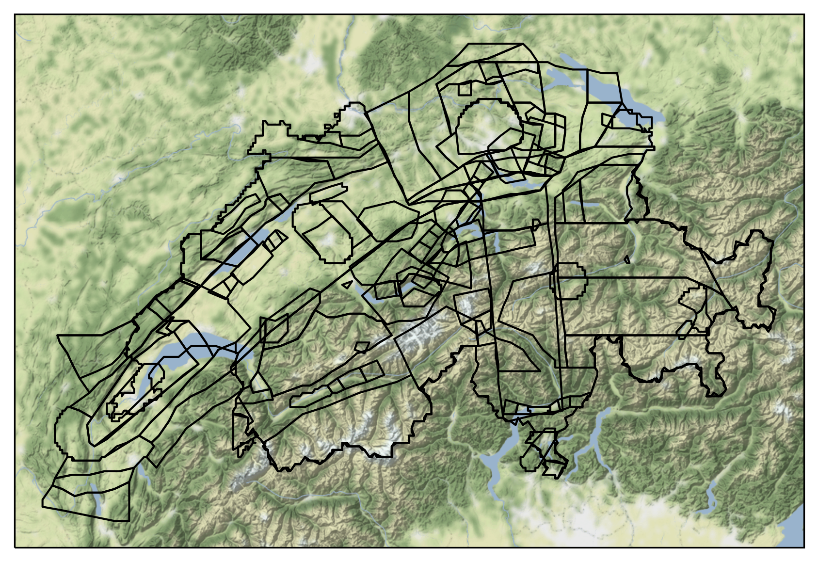
Visualising Airspaces
We can now plot the airspaces on a map, and plot the airspaces which intersect a given point.
fig = plt.figure(dpi=300, figsize=(7,7))

imagery = cimgt.Stamen(style="terrain-background")
ax = plt.axes(projection=imagery.crs)

minlon = 5.3
maxlon = 10.7
minlat = 45.5
maxlat = 48

ax.set_extent((minlon, maxlon, minlat, maxlat))
ax.add_image(imagery, 8)

ax.add_geometries(gdf.geometry, crs=ccrs.PlateCarree(), facecolor="none", edgecolor="black")

ax.set_aspect('auto')

plt.show()
def filter_gdf(gdf, long, lat, height=None):
    loc = Point(long, lat)
    if height is not None:
        return gdf[(gdf.lower_limit < height) & (gdf.upper_limit > height) & gdf.geometry.contains(loc)]
    else:
        return gdf[gdf.geometry.contains(loc)]
long = 8.567793
lat = 47.351863
gdf_filtered = filter_gdf(gdf, long, lat)


fig = plt.figure(dpi=300, figsize=(7,7))

imagery = cimgt.Stamen(style="terrain-background")
ax = plt.axes(projection=imagery.crs)

minlon = 5.3
maxlon = 10.7
minlat = 45.5
maxlat = 48

ax.set_extent((minlon, maxlon, minlat, maxlat))
ax.add_image(imagery, 6)

ax.add_geometries(gdf.geometry, crs=ccrs.PlateCarree(), facecolor="none", edgecolor="black")

ax.add_geometries(gdf_filtered.geometry, crs=ccrs.PlateCarree(), facecolor="none", edgecolor="red")
ax.scatter(long, lat, transform=ccrs.PlateCarree(), marker = "^", edgecolor="black", facecolor="white", s=100, zorder=10, label="Aircraft Location")

ax.legend(loc="upper right").set_zorder(100)
ax.set_aspect('auto')

plt.show()
Export Data
We save the data to a file.
from flight_processing import DataConfig
config = DataConfig.known_dataset("switzerland")
out_location = config.dataset_location
out_location
'/mnt/cold_data/josh/processing/regions_switzerland_wkt.json'
gdf_out = gdf.drop(['upper_limit_raw', 'lower_limit_raw', 'coords_raw', 'coords'], axis=1).copy()
gdf_out['wkt'] = gdf_out.geometry.apply(lambda g: g.wkt)

gdf_out.to_file(out_location, driver="GeoJSON")

del gdf_out