Importing the USA’s Airspaces
We import data on the USA’s airspaces from a dataset provided by the FAA. This data already contains all the information we need so it requires very little processing.
Setup
import requests
from datetime import datetime, timezone
import time
import numpy as np
import pandas as pd
import descartes, geopandas
from shapely.geometry import LineString, Point, Polygon, MultiPolygon, base
from shapely.ops import transform

import math
import matplotlib.pyplot as plt

import cartopy.crs as ccrs
import cartopy.geodesic as cgeo
import cartopy.io.img_tiles as cimgt
import cartopy.feature as cfeature
Initial Data Processing
We download the file using a built-in geopandas method, and do some basic processing to get the geometry and vertical limits into formats that the rest of the processing code can work with.
url = "https://opendata.arcgis.com/datasets/c6a62360338e408cb1512366ad61559e_0.geojson"
gdf = geopandas.read_file(url)
NOTE: as it turns out the z-coordinate is completely unused so
vertical_limits is unnecessary. I’m leaving it here in case it comes
in handy later.
def vertical_limits(geom):
    def _limits_from_coords(c):
        l = list(map(lambda t: t[2], list(c)))
        return (min(l), max(l))

    if isinstance(geom, Polygon):
        return _limits_from_coords(geom.exterior.coords)
    elif isinstance(geom, MultiPolygon):
        lims = list(map(list, zip(*[ _limits_from_coords(g.exterior.coords) for g in geom ])))
        return (min(lims[0]), max(lims[1]))
    else:
        raise NotImplementedError
def process_geometry(shape):
    shape2 = transform(lambda x, y, z: tuple(filter(None, [x, y])), shape).buffer(0)
    if isinstance(shape2, Polygon):
        return MultiPolygon([shape2])
    elif isinstance(shape2, MultiPolygon):
        return shape2
    else:
        raise NotImplementedError

def process_vertical_limits(upper, upper_units, lower, lower_units):
    if upper_units == "FT":
        upper_ft = int(upper)
    elif upper_units == "FL":
        upper_ft = int(upper) * 100
    else:
        upper_ft = 1000000 # Assume 'None' is unrestricted, this should be large enough
    if upper_ft < 0:
        upper_ft = 1000000 # See above

    if lower_units == "FT":
        lower_ft = int(lower)
    elif lower_units == "FL":
        lower_ft = int(lower) * 100
    else:
        lower_ft = 0 # Assume 'None' is unrestricted, return ground level
    return (upper_ft, lower_ft)

gdf['geometry'] = gdf.geometry.apply(process_geometry)
gdf['upper_limit'], gdf['lower_limit'] = zip(*gdf.apply(lambda row: process_vertical_limits(row.UPPER_VAL, row.UPPER_UOM, row.LOWER_VAL, row.LOWER_UOM), axis=1))
gdf['name'] = gdf['NAME']
del gdf['NAME']
gdf
| OBJECTID | GLOBAL_ID | IDENT | ICAO_ID | UPPER_DESC | UPPER_VAL | UPPER_UOM | UPPER_CODE | LOWER_DESC | LOWER_VAL | ... | AK_LOW | US_LOW | US_AREA | PACIFIC | Shape__Area | Shape__Length | geometry | upper_limit | lower_limit | name | |
|---|---|---|---|---|---|---|---|---|---|---|---|---|---|---|---|---|---|---|---|---|---|
| 0 | 1 | 2AC361E6-08A9-49E8-8B3B-AA68EE41363C | CZYZ | CZYZ | TI | 17999 | FT | MSL | None | 4500 | ... | 0 | 1 | 0 | 0 | 1.655436 | 7.583659 | MULTIPOLYGON (((-81.20495 44.50579, -81.20936 ... | 17999 | 4500 | TORONTO, ON CAE 8 |
| 1 | 2 | 3B2EA57E-2618-47A3-BC52-DF07A2DB6F97 | CZWG | CZWG | TI | 17999 | FT | MSL | None | 12501 | ... | 0 | 1 | 0 | 0 | 4.581230 | 8.016952 | MULTIPOLYGON (((-95.96780 49.79961, -95.96764 ... | 17999 | 12501 | KENORA, ON CAE |
| 2 | 3 | E229E560-CA7D-45A7-AFD6-9FF3E01113C6 | CZVR | CZVR | TI | 12500 | FT | MSL | None | 2000 | ... | 1 | 1 | 0 | 0 | 0.074797 | 1.798322 | MULTIPOLYGON (((-122.55477 49.10081, -122.5547... | 12500 | 2000 | PITT MEADOWS CAE |
| 3 | 4 | 7099FA1B-406E-4896-BA81-F74E30AECFCE | CZVR | CZVR | TI | 6500 | FT | MSL | None | 3200 | ... | 1 | 0 | 0 | 0 | 0.016077 | 0.598732 | MULTIPOLYGON (((-123.50967 49.37969, -123.5091... | 6500 | 3200 | VANCOUVER, BC TCA |
| 4 | 5 | 7FD391DB-1145-44CF-A32F-64B192FA284E | CZYZ | CZYZ | TI | 3300 | FT | MSL | None | 0 | ... | 0 | 1 | 0 | 0 | 0.030340 | 0.630070 | MULTIPOLYGON (((-76.71478 44.22523, -76.71477 ... | 3300 | 0 | KINGSTON, ON CTLZ |
| ... | ... | ... | ... | ... | ... | ... | ... | ... | ... | ... | ... | ... | ... | ... | ... | ... | ... | ... | ... | ... | ... |
| 5794 | 5795 | C471BE9C-6BBD-4DB6-8809-490E740EA021 | NOW | KNOW | TI | 2500 | FT | MSL | None | 0 | ... | 1 | 1 | 0 | 1 | 0.002927 | 0.197640 | MULTIPOLYGON (((-123.41226 48.11634, -123.4149... | 2500 | 0 | PORT ANGELES CGAS CLASS E2 |
| 5795 | 5796 | 4DCDB3FC-9149-4A58-B040-7F668E971B5D | NOW | KNOW | AA | -9998 | None | None | None | 0 | ... | 1 | 1 | 0 | 1 | 0.008285 | 0.475549 | MULTIPOLYGON (((-123.39775 48.11881, -123.3968... | 1000000 | 0 | PORT ANGELES CGAS CLASS E4 |
| 5796 | 5797 | D76D7CA4-4715-4991-AD59-DF1A7003A3EA | None | None | AA | -9998 | None | None | None | 700 | ... | 0 | 1 | 0 | 1 | 0.049059 | 0.895362 | MULTIPOLYGON (((-124.52673 42.55188, -124.4869... | 1000000 | 700 | GOLD BEACH CLASS E5 |
| 5797 | 5798 | F9D11D29-3001-4E66-A8C5-62BF1232E64B | None | None | AA | -9998 | None | None | None | 1200 | ... | 0 | 1 | 0 | 1 | 0.262581 | 1.855594 | MULTIPOLYGON (((-124.42158 42.16528, -124.4240... | 1000000 | 1200 | GOLD BEACH CLASS E5 |
| 5798 | 5799 | ECDCC2C9-DC4D-41A9-B17B-81C0D52FE798 | None | None | AA | -9998 | None | None | None | 700 | ... | 1 | 1 | 0 | 1 | 0.034226 | 0.855681 | MULTIPOLYGON (((-123.52795 48.22726, -123.2646... | 1000000 | 700 | PORT ANGELES CGAS CLASS E5 |
5799 rows × 42 columns
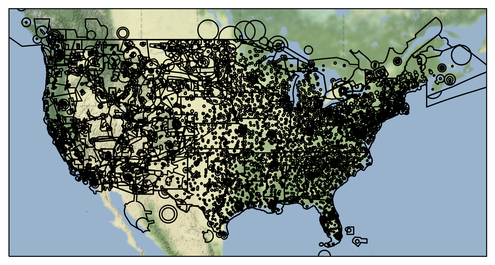
Visualising Airspaces
We can now plot the airspaces on a map.
fig = plt.figure(dpi=300, figsize=(7,7))

imagery = cimgt.Stamen(style="terrain-background")
ax = plt.axes(projection=imagery.crs)

minlon = -130
maxlon = -58
minlat = 23
maxlat = 46

ax.set_extent((minlon, maxlon, minlat, maxlat))
ax.add_image(imagery, 4)

ax.add_geometries(gdf.geometry, crs=ccrs.PlateCarree(), facecolor="none", edgecolor="black")

ax.set_aspect('auto')

plt.show()
Export Data
We save the data to a file.
from flight_processing import DataConfig
config = DataConfig.known_dataset("usa")
out_location = config.dataset_location
out_location
'/mnt/cold_data/josh/processing/regions_usa_wkt.json'
gdf_out = gdf.copy()

gdf_out['wkt'] = gdf_out.geometry.apply(lambda g: g.wkt)

gdf_out.to_file(out_location, driver="GeoJSON")

del gdf_out